
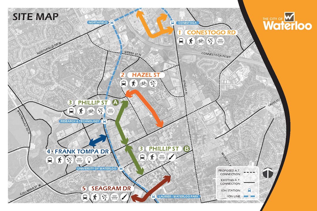
Five streets - designing for connectivity
The work from this project is now combined with the Farmer's Market Trail Stage 2 work for efficiencies and potential cost savings, and future updates will be listed under that project.
-------------------------------------------------------------
The City of Waterloo is undertaking a project to redesign five key streets which provide direct connections to ION stations in Waterloo. Help us make these spaces places that you want to explore and use.
These improvements were recommended in the 2017 City of Waterloo station area plans and will focus on improving pedestrian and cyclist access and connectivity as well as streetscape improvements.
Project update:
Public consultation has been an important part of this project and input was used to inform the final design. Thank you to everyone who live, work and play along or around these corridors for participating in one of our face-to-face engagement opportunities or who completed our online survey here. The pandemic had an impact on the project in 2020, however WSP has advanced the designs based on existing constraints and feedback and we are on track to tender the work. We have also decided to combine this work with the Farmer's Market Trail Stage 2 work for efficiencies and potential cost savings. This project will go to council again in spring 2021 to award the construction tender. Construction will begin thereafter, in the spring 2021.
-
Five streets: construction update
Share Five streets: construction update on Facebook Share Five streets: construction update on Twitter Share Five streets: construction update on Linkedin Email Five streets: construction update linkThe construction of multi-use-paths and related active transportation infrastructure on several city streets for this project has been approved, and a contractor has been retained to do the work for the city. These paths will help connect people to key destinations such as ION stations, places of employment and link users to the broader active transportation network. Weather permitting, we expect construction to happen between July and October, 2021. A short section of the Farmers Market Trail at the Weber Street intersection will be completed in 2022. This intersection will be reconfigured by the Region of Waterloo to accommodate the new Weber Street design. Details on the construction information can be found in the Document Library.
The multi-use-paths (MUP), will look similar to the one pictured.

Farmers Market Trail
The existing east side sidewalk along Parkside Drive will be replaced by a wider asphalt multi-use-path between Bearinger Road and Northfield Drive. Pedestrian scale lighting will be installed on this side of the street.

Phillip Street
A new asphalt multi-use-path will be constructed on the east side of Phillip Street between Columbia Street and Albert Street. Pedestrian refuge islands will also be installed to assist in crossing the street.

Conestogo Road
A new asphalt multi-use-path will be constructed on the west side of Conestogo Road between Northfield Drive and Bauer Place. Painted on-road bike lanes will also be installed up to King Street.

Bauer Place
A new asphalt multi-use-path will be constructed right up Bauer Place between Conestoga Road and King Street.

-
Consultation and design update
Share Consultation and design update on Facebook Share Consultation and design update on Twitter Share Consultation and design update on Linkedin Email Consultation and design update linkPublic consultation has been an important part of this project and input was used to inform the final design. Thank you to everyone who live, work and play along or around these corridors for participating in one of our face-to-face engagement opportunities or who completed our online survey here. The pandemic had an impact on the project in 2020, however WSP has advanced the designs based on existing constraints and feedback and we are on track to tender the work. We have also decided to combine this work with the Farmer's Market Trail Stage 2 work for efficiencies and potential cost savings. This project will go to council again in spring 2021 to award the construction tender. Construction will begin thereafter, in the spring 2021.
The following is an overview of each of the five streets that are being redesigned:


This project is reflected in our 2019-2022 strategic plan, specifically: Improve all modes of transportation to make Waterloo more mobile, accessible and connected. To learn more about our strategic plan, visit waterloo.ca/strategicplan.

Who's listening
-

Phone 519-747-6072 Email chris.dedman@waterloo.ca -

Email amanda.gebhardt@wsp.com