Downtown Cycling Grid
This project has concluded. On Dec 14, 2020 Kitchener City Council approved the downtown cycling grid, connecting the downtown core to adjacent neighbourhoods and regional cycling arteries. Public consultation showed a strong desire for better-connected cycling options downtown and for more people-friendly transportation options. The population in downtown continues to grow at a rapid pace in the downtown and many are looking for greater mode choice. The pandemic has also highlighted the demand for high quality cycling facilities as we adjust to the new norm. A downtown grid was identified as a necessary step in connecting Kitchener’s neighbourhoods together, and the community identified their preference of which streets would receive cycling upgrades in the downtown. Changes were made to the plan as a result of the latest round of communication, including changes to Joseph, Duke, Ontario and Water Streets.
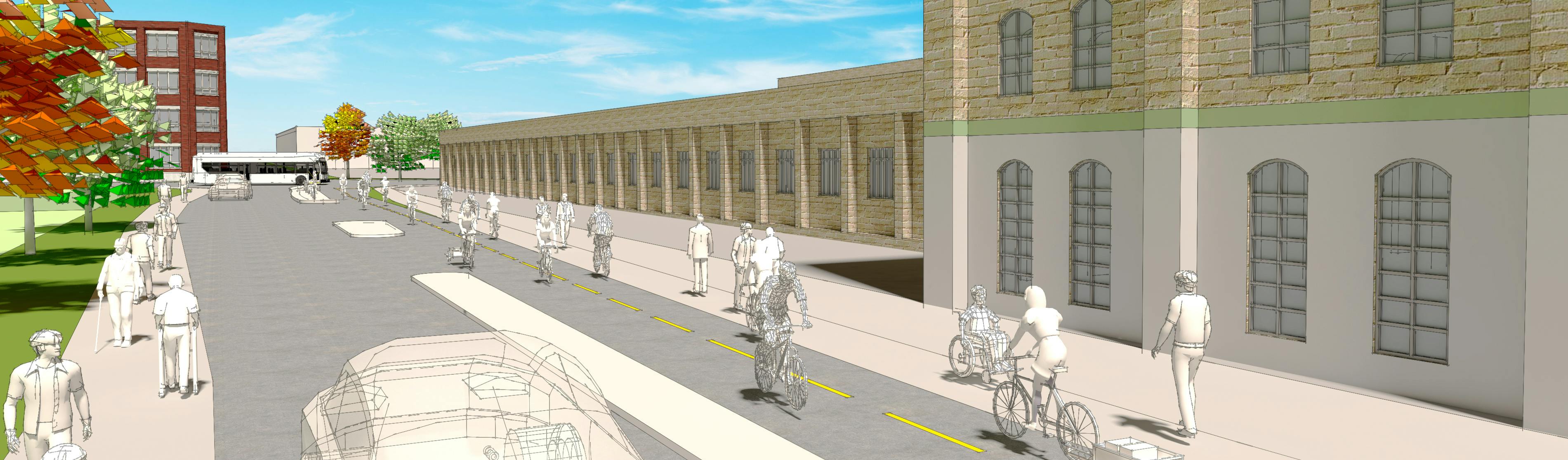
Following the input of over 4,000 residents through the city’s Strategic Plan and Cycling and Trails Master Plan, this project includes the installation of a continuous and protected cycling network that connects adjacent neighbourhoods to the downtown. Just like the ION LRT significantly reshaped the downtown, this project will transform how people move around by making it safe, comfortable, and convenient for people of all ages and abilities to bike. Cycling has been shown to generate economic activity for small businesses, can assist with physical distancing for transportation needs during the pandemic, and reduce carbon emissions. The Downtown Cycling Grid connects to popular trails like the Iron Horse Trail, Spur Line Trail, and the Great Trail, creating a new way for people to access all that downtown has to offer.
This project has concluded. On Dec 14, 2020 Kitchener City Council approved the downtown cycling grid, connecting the downtown core to adjacent neighbourhoods and regional cycling arteries. Public consultation showed a strong desire for better-connected cycling options downtown and for more people-friendly transportation options. The population in downtown continues to grow at a rapid pace in the downtown and many are looking for greater mode choice. The pandemic has also highlighted the demand for high quality cycling facilities as we adjust to the new norm. A downtown grid was identified as a necessary step in connecting Kitchener’s neighbourhoods together, and the community identified their preference of which streets would receive cycling upgrades in the downtown. Changes were made to the plan as a result of the latest round of communication, including changes to Joseph, Duke, Ontario and Water Streets.
-
Construction update: Spring 2024
Share Construction update: Spring 2024 on Facebook Share Construction update: Spring 2024 on Twitter Share Construction update: Spring 2024 on Linkedin Email Construction update: Spring 2024 link
The multi-use pathway on Margaret Street and Otto Street was completed in fall 2023, and has quickly become the busiest section of the Downtown Cycling Grid.
The final phase of construction is now underway, on key portions of Duke Street, connecting to existing cycling infrastructure on Water Street and Cedar Street, as well as providing access to public transit and the future transit hub. Construction is expected to take until the end of 2024.
Phase 1: Duke Street from Victoria Street to Water Street
Work on this stage includes: underground utility relocations within the roadway, new curb and gutter, new roadway asphalt, new driveway ramps, and new 3.0 metre wide bidirectional cycle tracks next to the sidewalk on the south side only. Please note: there will be periodic closures of the separated bike lanes on Water Street to accommodate construction of a new protected intersection.
Phase 2: Duke Street from Frederick Street to Cedar Street
Work on this stage includes: underground utility relocations within the roadway, new curb and gutter, new roadway asphalt, new driveway ramps, and new 3.0 metre wide bidirectional cycle tracks next to the sidewalk on the south side only.
To see the new street design, please see the construction drawings for Duke Street.
We look forward to wrapping up construction this year and formally celebrating this transformative project in spring 2025!
-
Construction update: Spring 2023
Share Construction update: Spring 2023 on Facebook Share Construction update: Spring 2023 on Twitter Share Construction update: Spring 2023 on Linkedin Email Construction update: Spring 2023 linkAt the end of 2022, construction was completed on Ontario Street and Cedar Street, marking the halfway point of building the Downtown Cycling Grid. Bike wayfinding was also installed on several routes, with more to come in 2023.

A contract has been awarded for the next stage of construction on Margaret Avenue and Otto Street. This route will fill an important connecting link to the Spurline Trail and several downtown neighbourhoods. Construction will begin in the spring and proceed in three stages:
-
Stage 1 – Margaret Avenue from Victoria St N to Queen St N
- Work on this stage includes: underground utility relocations within the roadway, new curb and gutter, new roadway asphalt, new driveway ramps, and new 3.0 metre wide bidirectional boulevard multiuse trail for both pedestrians and cyclists on the southwest side only.
-
Stage 2 – Otto Street from Queen St N to Frederick St
- Work on this stage includes: new curb and gutter, new driveway ramps, and new 3.0 metre wide bidirectional boulevard multiuse trail for both pedestrians and cyclists on the southwest side only.
-
Stage 3 - Margaret Avenue from Victoria Street N to Wellington Street N
- Work on this stage includes: new 3.0 metre wide bidirectional cycling lane on the existing roadway created by installation of new line markings and precast barriers on southwest side only.
In addition, under a separate contract, installation of a multi-use trail is planned for Stewart Street (Park Street to end) and Joseph Street (end to Victoria Street) to connect the Downtown Cycling Grid with the Transit Hub Trail and Iron Horse Trail.
The final stage of construction includes sections of Duke Street and will proceed in 2024.
-
Stage 1 – Margaret Avenue from Victoria St N to Queen St N
-
Construction update: Spring 2022
Share Construction update: Spring 2022 on Facebook Share Construction update: Spring 2022 on Twitter Share Construction update: Spring 2022 on Linkedin Email Construction update: Spring 2022 linkConstruction continues on Kitchener's Downtown Cycling Grid. In 2021, separated bike lanes were installed on Joseph Street and Water Street. Give them a try today!
 Joseph Street separated bike lanes, now open!
The following work is scheduled for 2022:
- Joseph Street & Water Street - remaining pavement markings, bike rack installation, counter installation, minor deficiency repairs
- Queen Street (Joseph to Church) - separated bike lanes
- Ontario Street (Joseph to King) - separated bike lanes
- Cedar Street (Church to Lancaster) - separated bike lanes
- Lancaster Street & Chapel Street - neighbourhood bikeway traffic diversion
- Breithaupt Street, Lancaster Street, Chapel Street, Sydney Street, Bedford Road, David Street, Duke Street East, Pandora Avenue, Stirling Lane - neighbourhood bikeway wayfinding
To see the design and scope of construction, please review the 2022 Construction Drawings for Ontario Street & Cedar Street or 2022 Construction Drawings for Queen Street. Please note drawings are subject to change as construction develops.
In addition, under a separate contract, installation of a multi-use trail is planned for Stewart Street (Park Street to end) and Joseph Street (end to Victoria Street) to connect the Downtown Cycling Grid with the Transit Hub Trail and Iron Horse Trail.
Happy riding!
-
Cycling network map
Share Cycling network map on Facebook Share Cycling network map on Twitter Share Cycling network map on Linkedin Email Cycling network map linkApproved cycling routes
-
Water Street
Share Water Street on Facebook Share Water Street on Twitter Share Water Street on Linkedin Email Water Street link
-
Joseph Street
Share Joseph Street on Facebook Share Joseph Street on Twitter Share Joseph Street on Linkedin Email Joseph Street link


Documents
-
 Safety Review 2024 (12.3 MB) (pdf)
-
Active Transportation Progress Report 2023 (11.6 MB) (pdf)
-
Duke_Pavement Markings (IFC).pdf (2.81 MB) (pdf)
-
Downtown Cycling Grid Project Information.pdf (10.6 MB) (pdf)
-
DCN_Margaret_2022-10-26.pdf (18.5 MB) (pdf)
-
Ontario & Cedar construction drawings (3.27 MB) (pdf)
-
Frequently Asked Questions About Cycling (204 KB) (pdf)
-
DTK Cycling Grid Online survey responses (2.97 MB) (pdf)
-
Downtown Cycling Grid: Motor Vehicle Traffic Study (16.4 MB) (pdf)
-
Downtown Cycling Grid: What we heard (354 KB) (pdf)
-
Queen Street construction drawings (4.8 MB) (pdf)

Who's Listening
-
Phone 5197412200 x7314 Email darren.kropf@kitchener.ca