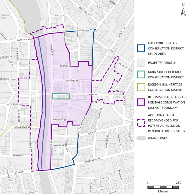
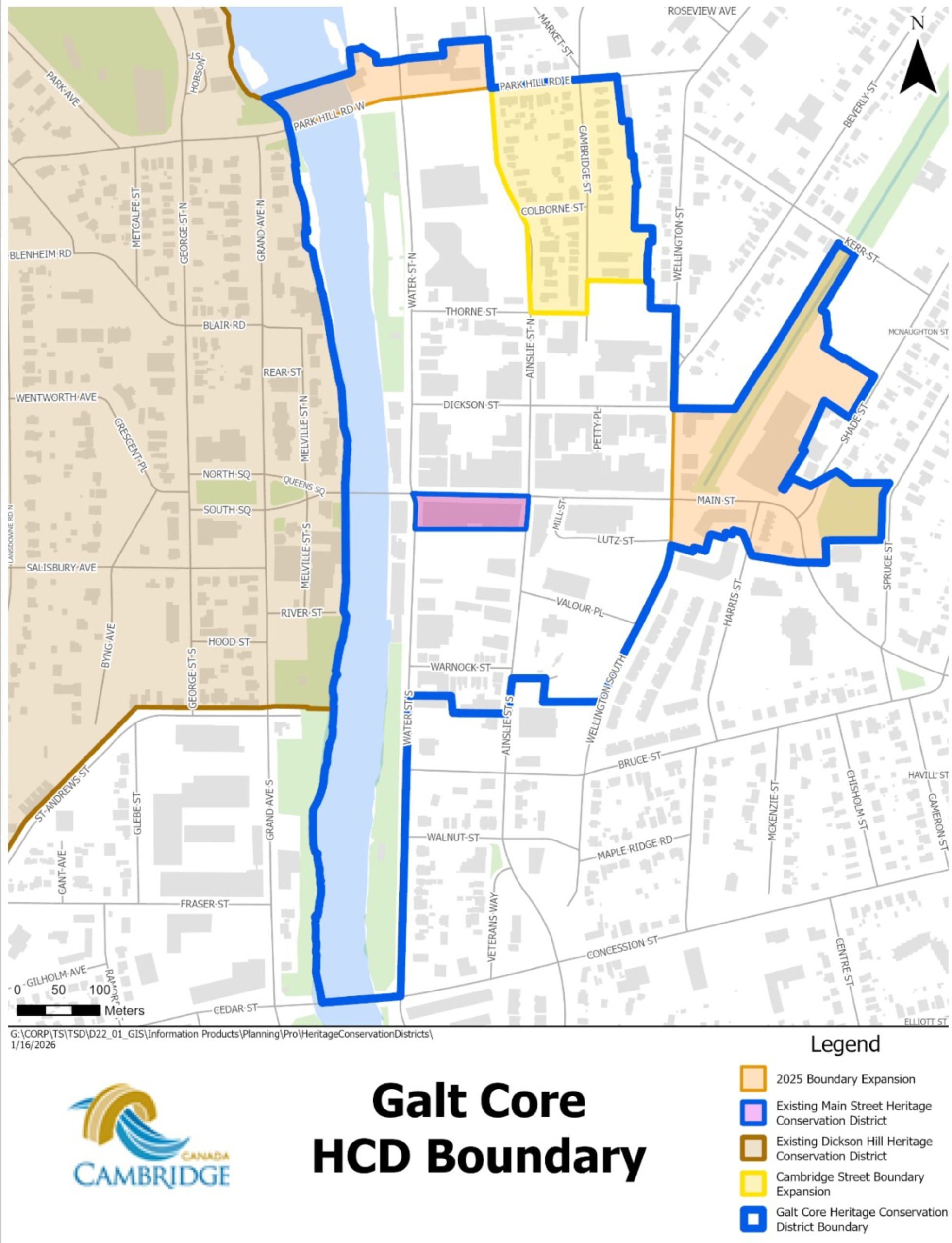
Welcome to the Galt Core Heritage Conservation District

Picture of Galt Core

An overview of Downtown Galt containing a rich collection of buildings, streetscapes, and landscape features that together tell the story of Galt’s beginnings on the banks of the Grand River in the nineteenth century. These features, the stories they convey and the sense of place that they create, are valued by the local community and are of significant cultural heritage value as a distinct area.

Current Galt Core HCD Plan 2025 Documents

Get Involved!

Community engagement is integral to the success of a Heritage Conservation District (HCD) Plan. People who live and work in the area can identify important characteristics of the area and elements that should be retained and celebrated. Consultation also allows for members of the community to express what new development within the District should look like and how best to implement recommended policies and guidelines. The Plan’s engagement program encouraged active discussions with community members and property owners and provided opportunities to participate in the process and provide comments and feedback.

For inquires about the Galt Core HCD Project, please send them to heritageinfo@cambridge.ca.

Additionally, a Question and Answer section can also be found in the Detailed FAQ at the end of the page :)


Council Calendar

Please check the Council agenda to review the date and time details through here. A presentation by staff will also be available online at this link prior to the meeting. Copies of the plan and the staff report will be available on the City of Cambridge Council Calendar where meetings are posted and agenda materials can be found.

Common FAQs


An HCD is a geographically defined area within a municipality that is noted for its distinct heritage character.

An HCD may be defined by neighbourhoods or other locations with distinct features, styles, themes, or characteristics. HCDs can include buildings, trees, roads, landscapes and other elements that contribute to their unique character.

Under Part V of the Ontario Heritage Act, municipalities can protect districts by designating character-defining elements and their public realm, providing detailed guidance for redevelopment that occurs over time.


The purpose of designation is to guide physical change over time so that it protects heritage elements and character.

Designation recognizes and reinforces the community value of heritage properties, provides protection against inappropriate changes to heritage properties, controls demolition, and gives heritage property owners access to limited financial assistance for maintenance and restoration works.

The purpose of heritage designation is not to prevent changes to the property, but to manage it so that the attributes and characteristics which make the property special are retained, celebrated, and respected. This is to ensure that they complement, rather than compromise, the integrity of the property’s cultural heritage value.

Designation can apply to both individual properties or districts.


The boundaries for the plan were determined based on historical mapping and areas of concentration of historic building stock found from our HCD Study in 2021 as well as further and refined research performed between 2023 - 2025. The study area also incorporates residential, commercial, and industrial portions.


Several academic studies have shown that heritage designation is positively correlated with improvements in residential property values (see Robert Shipley, 2000; Paul Shaker, 2019; and Rebecca Correia et al., 2023)

Heritage Conservation Districts help to guide the type of infill, urban design, beautification, alterations, and conservation that should occur in the District. Change is not regulated and guided through the Heritage Permit process, but not prohibited. A Heritage Conservation District in the Galt Core will ensure that future developments and renovation in the boundary complement the District's character. The HCD can also generate tourism and enhance Galt's identity, pride, and civic involvement.

Finally, all property owners of designated properties within an HCD are eligible for the City's Designated Heritage Property Grant Program which enables the reimbursement of monies spent on property upkeep or restoration work up to a maximum of $5,000 per calendar year. The application form can be accessed online and is available here.


An updated draft HCD Plan was released and presented in November 2025 for final consultation. Comments were received that the boundary should be refined, with some comments seeking a larger boundary and some suggesting that the district was too large.

Staff continue to recommend the district boundary as shown in the November 2025 draft plan and guidelines with minor refinements in response to comments received through consultation and the Statutory Public Meeting, specifically to include Cambridge Street within the district.

The Galt Core Heritage Conservation District Plan identifies the HCD’s character-defining elements and outlines how these should be conserved and enhanced. It provides a framework for assessing alterations, new development, and public realm improvements to ensure they are compatible with the HCD’s heritage character. It balances the need to accommodate growth with the need to preserve downtown Galt’s unique identity.

Galt Core November 2025 with Expanded Area Changes

Galt Core Plan with 2026 Expanded Boundary Changes

Got Questions and Comments?


Heritage Conservation District Process

There are two phases; The Heritage Conservation Study then the Heritage Conservation Plan.

  • Study Phase

    The first is a heritage conservation district study phase which examines the history and character of the area and its buildings and structures. The study makes recommendations as to whether the area should be designated as a district and what its boundaries should be.

  • Plan Phase

    If the study recommends designating the area as a district, the second step is a heritage conservation district plan. The plan is developed, in consultation with the local community, and includes policies policies for conserving and enhancing the district's character.

A heritage conservation district study involves detailed research of an area to understand whether it holds heritage significance, and what makes it significant. This process includes:

  • Conducting historical research to uncover historic themes and events that have shaped the area over time;
  • A property survey evaluating the area’s architecture, distinctive property features, views, streetscapes, and topography;
  • Evaluation of the existing policy framework and heritage protection for the district;
  • Public consultation sessions to receive input from the community about why the area is significant to them.

The study must use this information to make key recommendations including:

  • Whether the area holds enough significance to be designated as a Heritage Conservation District;
  • A draft statement of significance explaining why the district is significant;
  • A draft district boundary; and,
  • Draft objectives for a Heritage Conservation District Plan.

The study is then presented to the municipal Council to decide if a Heritage Conservation District Plan should be prepared.

A heritage conservation district plan is prepared to help manage change in the district to ensure that the district’s significance is conserved and enhanced. The plan must contain:

  • A statement of objectives to be achieved in the designation of the area as a heritage conservation district;
  • A statement of the district’s cultural heritage value or interest;
  • A description of the district’s heritage attributes and those of properties within the district;
  • Policy statements, guidelines, and procedures for achieving the stated objectives and managing future changes;
  • Description of alterations that are minor in nature that an owner can carry out without obtaining a permit.

The plan will be designed to conserve and enhance the value that was identified by the heritage conservation district study. Draft policies and guidelines are refined through public consultation.

When a Heritage Conservation District Plan is complete, a statutory public meeting is held at which the public can provide comments on or objections to the plan.

Council may then pass a designation by-law under Part V of the Ontario Heritage Act which puts the plan into force.


Archive and Project Background

Please review the important Documents links, which includes the Public Engagement information found below.

Flooding in Downtown Galt 1929 (City of Cambridge)

Flooding in Downtown Galt 1929 (City of Cambridge)

Main Streets looking west 1910 (Toronto Public Library)

Main Streets looking west 1910 (Toronto Public Library)

Project Background Details

The Study was initiated in January 2021 to assess the defined study area in detail and to determine if it merits conservation as a HCD, through designation under Part V of the Ontario Heritage Act (OHA).

The final Study report was completed in June 2021 and recommended that the City of Cambridge proceed to prepare an HCD Plan in Galt’s downtown core.

On July 27th, 2021, Cambridge City Council recommended that an HCD Plan be prepared for lands located within the boundary. The HCD plan was finalized in January 30, 2023 with a Public Information Centre #3 on February 15, 2023.

Working from the results of the HCD Study, and with the District boundary as approved by Council, this HCD. Plan was prepared in accordance with the Ontario Heritage Act and the Ontario Heritage Tool Kit - Heritage Conservation Districts (Ministry of Citizenship and Multiculturalism, 2025).

The development of the Plan included the identification of contributing and non-contributing properties, and outlining objectives, policies, and design guidelines that support the conservation and enhancement of the District.

These were developed and refined in collaboration with City staff and the Project Steering Committee and through public and stakeholder engagement. The Plan was also developed in consultation with project teams working on the concurrent Growth and Intensification Study, to ensure that the studies would inform and complement each other.

However, during the final phase of the plan, changes were made to the Ontario Heritage Act under the More Homes Built Faster Act, 2022 (Bill 23) resulting in new requirements for HCDs. Bill 23 came into effect starting on January 1, 2023. Shortly thereafter, the project was paused to consider modifications to the district boundary and ultimately re-initiated in Q2 2025.

An important change was the Ontario Heritage Act Regulation 9/06 (O. Reg 9/06) Criteria for Determining Cultural Heritage Value or Interest require that at least 25% of the properties within an HCD must meet two or more criteria in the regulation in order to be designated, changing the methodology in evaluating HCDs.

As the majority of the Galt Core HCD Study and Plan work occurred prior to January 1, 2023, this Plan has been supplemented with an updated evaluation table documenting how the District meets criteria under O. Reg 9/06 within the Volume 2 of the HCD Plan June 2023.

Statements of contribution for individual properties are available upon request from City staff where Statements of contribution provide a rationale for how each contributing property demonstrates or supports the cultural heritage values and integrity of the HCD. They also help to determine how the policies and guidelines of the HCD Plan apply to each contributing property.

In Spring 2025, the project was re-initiated and opportunities to expand the boundary were studied; the area north of Park Hill Road and the area east of Wellington Street. It was determined that these areas warrant inclusion in the final HCD boundary and endorsed by council to be included amidst the development of the Plan phase.

Based upon best practices in heritage conservation designation and assessment of the areas surrounding the HCD boundary, the consultants recommend adding several properties and landscape features along Water Street North and Park Hill Road East and along Main Street east of Wellington Street. A total of nine (9) properties are recommended to be added to the boundary including Centennial Park. Seven (7) of these properties were found to hold significant cultural heritage value to warrant inclusion into the HCD boundary area as contributing properties. There are two (2) properties proposed to be included in the expanded boundary as non-contributing properties. The modified boundary comprises a total of 146 individual property parcels. The draft plan and guidelines has been updated to include these proposed modifications to the boundary.

Timeline of Galt HCD Project

  • Galt City Centre has been identified as an area with heritage significance within the City of Cambridge since at least the 1980s. In 1985, the Main Street Heritage Conservation District was designated, recognizing the significance of a block of commercial buildings on the south side of Main Street between Ainslie and Water Streets.
  • In 2008, The City of Cambridge Heritage Master Plan recognized Galt City Centre as a heritage “character area” and recommended further evaluation
  • In 2013, the City adopted Downtown Urban Design Guidelines which recommended that the existing Main Street Heritage Conservation district be expanded to encompass a greater area. Main Street Urban Design Guidelines that recognized the special heritage character of Galt City Centre were also adopted at this time.
  • Through 2018, consultation was conducted to determine public support of a potential Heritage Conservation District Study for Galt City Centre and to establish study area boundaries. This consultation indicated public support for a Heritage Conservation District Study
  • On October 9, 2018 The City of Cambridge Planning and Development Committee approved the commencement of the Galt Heritage Conservation District Study in 2020 subject to future capital budget approval
  • The Galt Core Heritage Conservation District Study was completed in July 2021.
  • On October 5, 2021 Council endorsed the Galt Core Heritage Conservation District Study and approved work to begin on a Heritage Conservation District Plan.
  • On 28 July 2020, Cambridge City Council directed staff to begin the Galt Core Heritage Conservation District Study.
  • On July 28, 2020 Council directed staff to initiate the Galt Core Heritage Conservation District (HCD) Project through Report 20-191(CD). The City retained ASI in collaboration with Fotenn Planning and Design and Stevens Burgess Architects in January 2021 to assist with the preparation of an HCD study and plan.
  • The initial Study Phase concluded in October 2021 with Council endorsement of the recommended HCD boundary and the direction to prepare the Galt Core HCD Plan and Guidelines in accordance with Part V, Section 41 of the Ontario Heritage Act through Report 21-184-CD
  • A draft Plan and Guidelines was prepared and released to the public in January 2023. Public Information Centres were held on February 15, 2023 (virtually) and March 8, 2023 (in person), to present the draft HCD Plan.
  • Shortly thereafter, the project was paused to consider modifications to the district boundary and ultimately re-initiated in Q2 2025.
  • Through the study phase of the project, a recommended boundary for the Galt Core HCD was endorsed by City Council and the study was approved to move forward to the Plan phase.
  • Following initiation of the Plan phase, additional areas were proposed for consideration of inclusion within the boundary and the project was paused to consider the proposal. In Spring 2025, the project was re-initiated and opportunities to expand the boundary were studied.

Study Area

The area that was evaluated as part of the Galt Core Heritage Conservation District Study included all of the lands east of the Grand River, south of Park Hill Road, west of Wellington Street and north of Concession Street. After being evaluated, the authors of the study recommended a revised boundary for the proposed district that excluded the lands north east of the intersection of Ainslie Street and Thorne Street, and those south east of the intersection of Water Street and Thorne Street. The recommended district boundary and the original study area boundary are mapped below. This boundary was chosen because the recommended boundary outlined below was chosen because it includes an expression of:

  • Key portions of the river valley edges;
  • A cohesive collection and grouping of the area’s civic, institutional, industrial, religious and residential buildings, landscape features, structures, and streetscapes that together tell the story of Galt’s early nineteenth-century development, later growth and community solidification in the early twentieth century as a picturesque community, regional hub in Waterloo County, and important industrial centre on the Grand River corridor and Grand Trunk Railway network.
  • An excellent combination of features that together establish an important setting for the downtown through its inclusion of landmark buildings, exceptionally high quality and unique stone masonry structures, open spaces and public squares, streetscapes, long-range views, and circulation networks.

Chronological History and Evolution

The Galt Core HCD Study Area is strongly defined by the Grand River. For thousands of years, the Grand River and its tributaries, including Mill Creek, influenced where and how people travelled, where people settled, and where people farmed or developed industries. Lots were laid out perpendicular to the river, in an east-west direction in this area, as opposed to a north-south axis throughout the rest of the Township. The point where Mill Creek meets the Grand River was selected by William Dickson and Absalom Shade as an ideal location for settlement in 1816. Nestled in the river valley with relict shorelines to the east and west, the early settlement of Shade’s Mills/Galt quickly grew as a town site, supporting the early settlers attracted to the fertile soil in the surrounding countryside. Indeed, the community became a regional hub, providing commercial and civic/institutional services to residents and visitors alike.

The Grand River and the construction of the Galt Dam and Mill Race Canal in 1837 provided waterpower for anticipated factories, setting the stage for Galt’s growth and economic development in subsequent decades. Galt quickly established itself as an industrial town with a diverse array of industry, including textile factories, edge tool works, flouring mills, foundries, tanneries, and other varied sites. Besides being known as “The Granite City” for its stone buildings (Dilse 1981), it also became known as the “Manchester of Canada.” The town’s industrial might contributed to its economic growth and social development between the 1860s and the turn of the century. During this time, industry was especially concentrated on Water Street North and around the railway corridor adjacent to Mill Creek. Galt’s downtown core was always much more than an industrial centre, though. Indeed, it was a central location for social and cultural gatherings, for commerce, and for civic involvement, all of which fostered a bustling community which served both locals and the surrounding rural countryside. Galt continued to grow rapidly in all directions from its historical core well into the twentieth century.

While some key industrial facilities closed in the post-Second World War period, manufacturing operations continued to be the most important form of employment during that time. In particular, Galt’s textile industry remained an important sector within the Study Area. Overall, however, the postwar period marked the beginning of the decline of major industry within the Study Area boundary. Like elsewhere in Ontario, downtown factories were getting phased out and suburban factories emerged which could be served by both railways and transport trucks. Many industries decided to open or move operations north of the Study Area in proximity to Highway 401, which opened in 1960.

The City of Cambridge was formed in 1973 through the amalgamation of Galt, Hespeler, Preston, Blair, and parts of the Townships of North Dumfries and Waterloo. Galt had always been a civic hub and that continued when its downtown was chosen as the location of Cambridge’s new municipal offices. The former City of Galt, like much of the rest of Canada, experienced economic stagnation, and industrial decline in the 1970s and 1980s. As industry left the area, many industrial buildings were demolished but others were repurposed for other uses. The historical core of Galt still features a number of landmark civic and institutional buildings, as well as commercial and residential structures that are directly associated with that industrial past.

Through it all, the Galt Core HCD. Study Area continued to be defined by the Grand River. Following a massive flood in 1974, many riverside industrial buildings were demolished and replaced by concrete walls, earth berms, and other flood protection measures. Mill Race Park was completed on these former industrial lands, on the site of the original Mill Race Canal. Today, Mill Race Park and the Grand River forms the backdrop to many social events and gatherings in Galt. The Park is also the site of the official Grand River Canadian Heritage River Designation plaque.

What is a Municipal Register of Cultural Heritage Properties?

Municipalities must keep a Register of Heritage Properties that are of cultural heritage value or interest: this is an official list of properties that have heritage value or character for the community. The Register (sometimes also referred to as Heritage Inventory) notes properties that are Listed (S.27, Part IV), in a District (S.41, Part V) and Designated (S.29, Part IV) under the Ontario Heritage Act. The City of Cambridge Heritage Register consists of nearly 1,150 properties. The Register has legal status and can provide limited protection to these heritage resources, as follows:

Documents, Reports, and Updates