
FAQs
Will a pathway/park be built along the creek?
This project is for an Environmental Assessment (EA). The EA will look at options to naturalize the creek. These options include ripping up the concrete channel, adding trees, and allowing the creek to meander. At this point there is nothing planned for a park or additional pathways along the creek. The Iron Horse Trail alignment may be adjusted. However, this trail will continue to function as an important artery.
Update after the third Public Information Centre: Design Options 2a and 2b include an expanded trail along Shoemaker Creek and an extension of the trail network from Courtland Avenue to the Iron Horse Trail. If one of these options is chosen as the preferred option, these new segments of trail will provide a great connection from the Iron Horse Trail to the Mill St and Ottawa St S area, connecting you to the Mill Station ION.
Will you retain existing trees?
We hear your feedback about the importance of keeping existing trees. Design options for the creek will be developed this summer. In the fall, the design options will be presented for public feedback. The Environmental Assessment will include the preferred design option. The chosen design option will determine which trees will be retained, and outline locations for new trees to be planted.
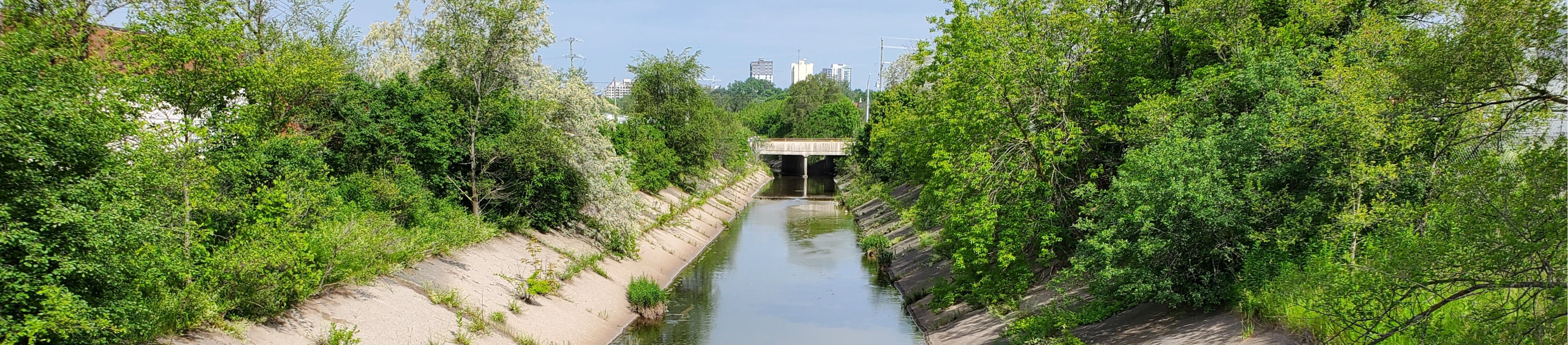
The concrete is in good shape and I haven't experienced flooding, so why is this project happening?
Concrete channels drain water to the Grand River as fast as possible. This creates flooding and erosion downstream. Concrete channels also create barriers for fish. Naturalizing these channels provides many benefits. Aquatic habitat, aesthetics, and water quality can all be improved.
Will Shoemaker creek be brought aboveground at the Schneider plant?
At this point there are no plans to bring Shoemaker Creek above ground where it runs underneath the Schneider plant. This is known as 'daylighting' the creek.
Will this project close nearby roads?
The Environmental Assessment (EA) and creek restoration design is not finished. Depending on the chosen design, creek construction could affect roads around bridges. This construction may occur in 2025.
Public Information Centre #1 Questions
- The project website on Engage will be updated
- An email will be sent out to the Engage project mailing list
- Letters will be mailed to residents
- Posters will be put up around the creek
Will the concrete be removed? What would it be replaced with?
One of the options includes ripping up the concrete and replacing it with a meandering creek bed. This creek bed would be naturalized, with stones and sand replacing the concrete.
Why would you replace the concrete?
Concrete channels drain water to the Grand River as fast as possible. This creates flooding and erosion downstream. Concrete channels also create barriers for fish. Naturalizing these channels provides many benefits. Aquatic habitat, aesthetics, and water quality can all be improved.
How will this project address invasive / native species?
The project team will look for ways to remove invasive species from the site. A team of environmental engineers and biologists will be involved with the designs. This team will suggest appropriate native species for planting.
Will existing trees be retained?
We hear how important it is to retain existing trees. Design options for the creek will be developed this summer. In the fall, the design options will be presented for public feedback. The Environmental Assessment will include the preferred design option. The chosen design option will determine which trees will be retained, and outline locations for new trees to be planted.
Why naturalize the creek now?
The Integrated Stormwater Master Plan (2016) looked at stormwater across the city. This plan identified Schneider Creek as a good place to naturalize. Naturalizing the creek improves safety and reduces the risk of flooding. This project is happening now because of recent funding from the federal government. This funding has enabled the City to bring this project forward through the Environmental Assessment process.
How will the City pay for the project?
This project is part of a series of stormwater management projects that the City of Kitchener is working on. It is partially funded by the federal government’s Disaster Mitigation and Adaptation Fund (DMAF). 40% of funding for this project will come from the federal government.
How will decisions be made and how will resident input be considered?
Why did residents outside of this neighbourhood receive project letters?
We want input from nearby property owners. Local residents will continue to receive information about the project. We will also consult with residents outside of the neighbourhood. Many people use the Iron Horse Trail to commute to work and for recreation, and we want their input as well.
How will existing litter in the area be addressed and how could the City prevent littering on the new naturalized creek?
The City is part of a litter reduction task force with several other municipalities. You can report park litter to the City through this litter report form. You can read more about the City of Kitchener's litter bylaw here:
What is the timeline of the project?
A broad timeline of the project can be found on the Engage Kitchener website. The next step is to develop alternative design concepts. These concepts will be shared at a second public open house for feedback.
How will residents be notified of alternative design concepts?
How long will the Environmental Assessment last? What is the purpose of an Environmental Assessment?
The Environmental assessment (EA) will continue to the end of 2023. The EA will review the condition of the creek and look at the potential impacts of the project. Through this process we will choose a preferred solution for creek naturalization.
Will the City add additional recreational spaces near the project area?
Thank you for all your suggestions for added recreational area. We will consider these in the designs where feasible and where funding permits.
Will the City consider the upstream and downstream areas or remove the culvert under an adjacent private property?
Upstream and downstream areas and culvert removal are outside the scope of the project. There are strategies available to make culverts more easily navigable by fish. We will investigate this potential.
What will the temporary impacts as a result of construction be?
Once a preferred solution is chosen through the EA process we'll move into a design phase. We will seek the public's feedback on ways to mitigate the impact of construction at that time.