Connected living
Building a grid-network of streets that prioritizes access to the community through active transportation and transit connections and deprioritizes the role of the private car.

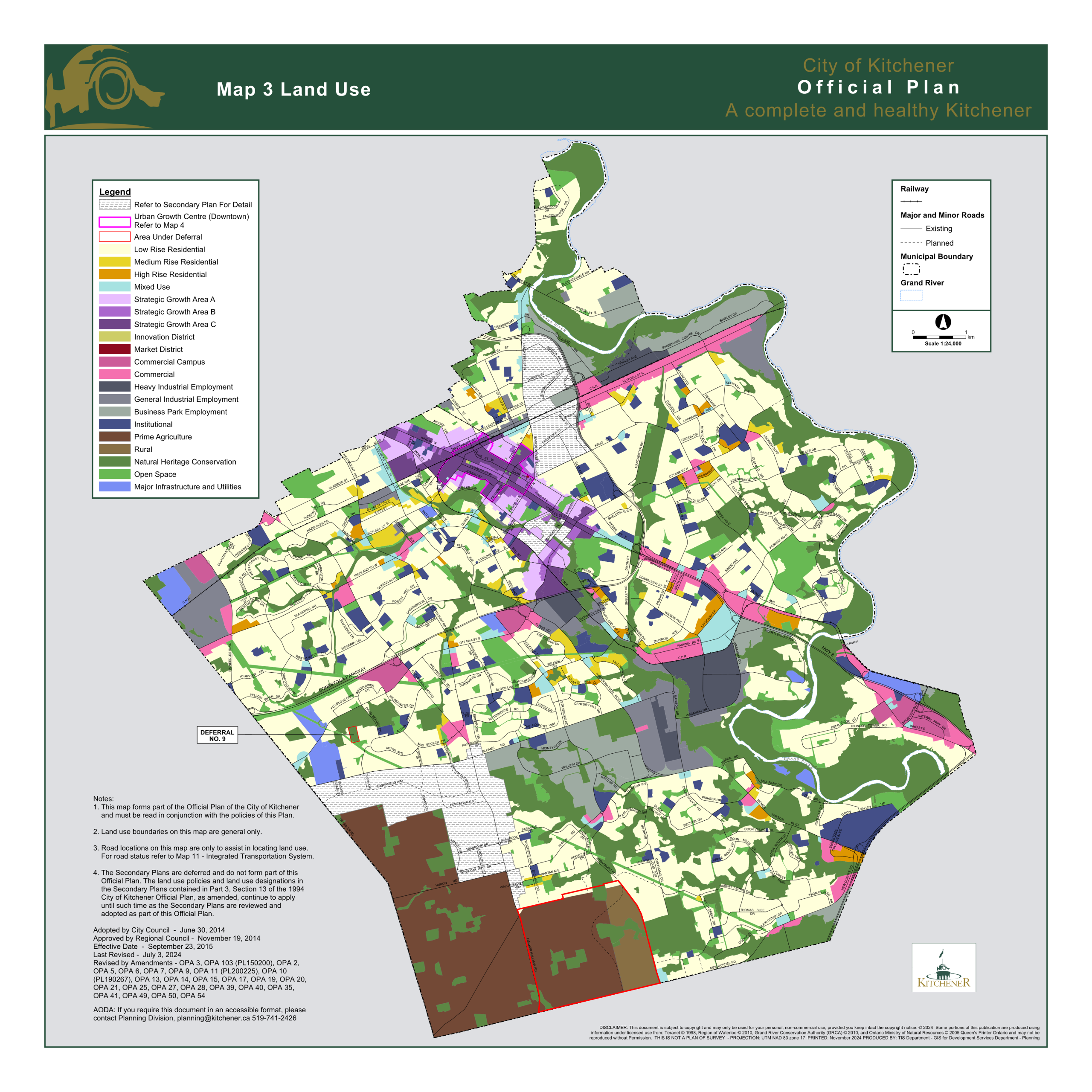
The Dundee area is bounded by the limits of the Huron South Subdivision to the north, New Dundee Road to the south, Fischer Hallman Road to the west, and Reidel Road to the east.
The map outlines the study area on the land use map of Kitchener, the community located in the southwest part of Kitchener.
Dundee is approximately 460 hectares, which includes approximately 50 hectares of natural heritage area. That leaves a net developable land area of approximately 410 hectares. Currently, most of the land in this area is used for farming or is environmentally protected.
To accommodate the forecasted population and employment growth in Kitchener by 2051, the Dundee community is being planned for approximately 34,440 people and jobs. That's comparable to the population of Stratford or Orangeville.
We have developed two land use scenarios to guide future development of the Dundee community. We are considering many things including:
We'll share more details about these big moves in the next section.
The big moves are large scale and long-term actions that will guide development in the new community. They help address issues or take advantage of opportunities within the community. These are what will shape the layout of the community.
Building a grid-network of streets that prioritizes access to the community through active transportation and transit connections and deprioritizes the role of the private car.
Creating an integrated public realm, which includes important stormwater management areas, parks, and natural heritage features, which serve multiple purposes.
Being innovative in how energy is supplied to this new community and exploring new technologies to reduce its long-term dependance on fossil fuels.
Fostering a new core area that supports higher densities and includes amenities and services, which creates a destination that people visit.
Creating focal points in every neighbourhood where people can gather, spend their morning, or access day-to-day services and amenities.
Here are more details about the two scenarios we developed. Please note that these scenarios portray approximate land use locations that will be refined through ongoing technical work.
To view information about each scenario, including an interactive map, click the tabs.
Move the slider back and forth to compare Scenario A (left) with Scenario B (right)

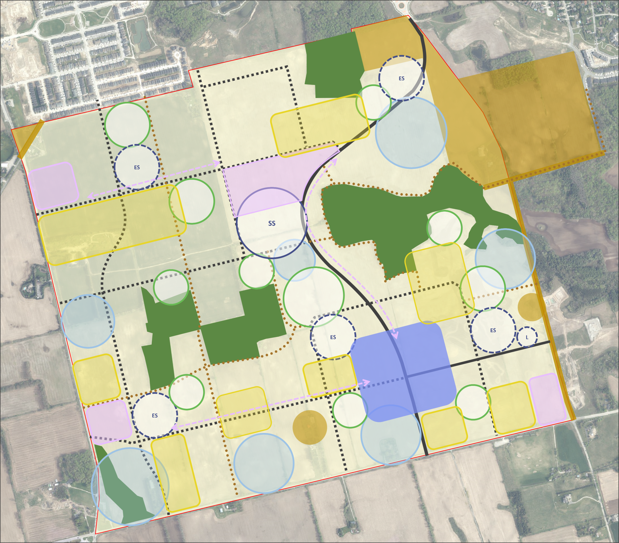
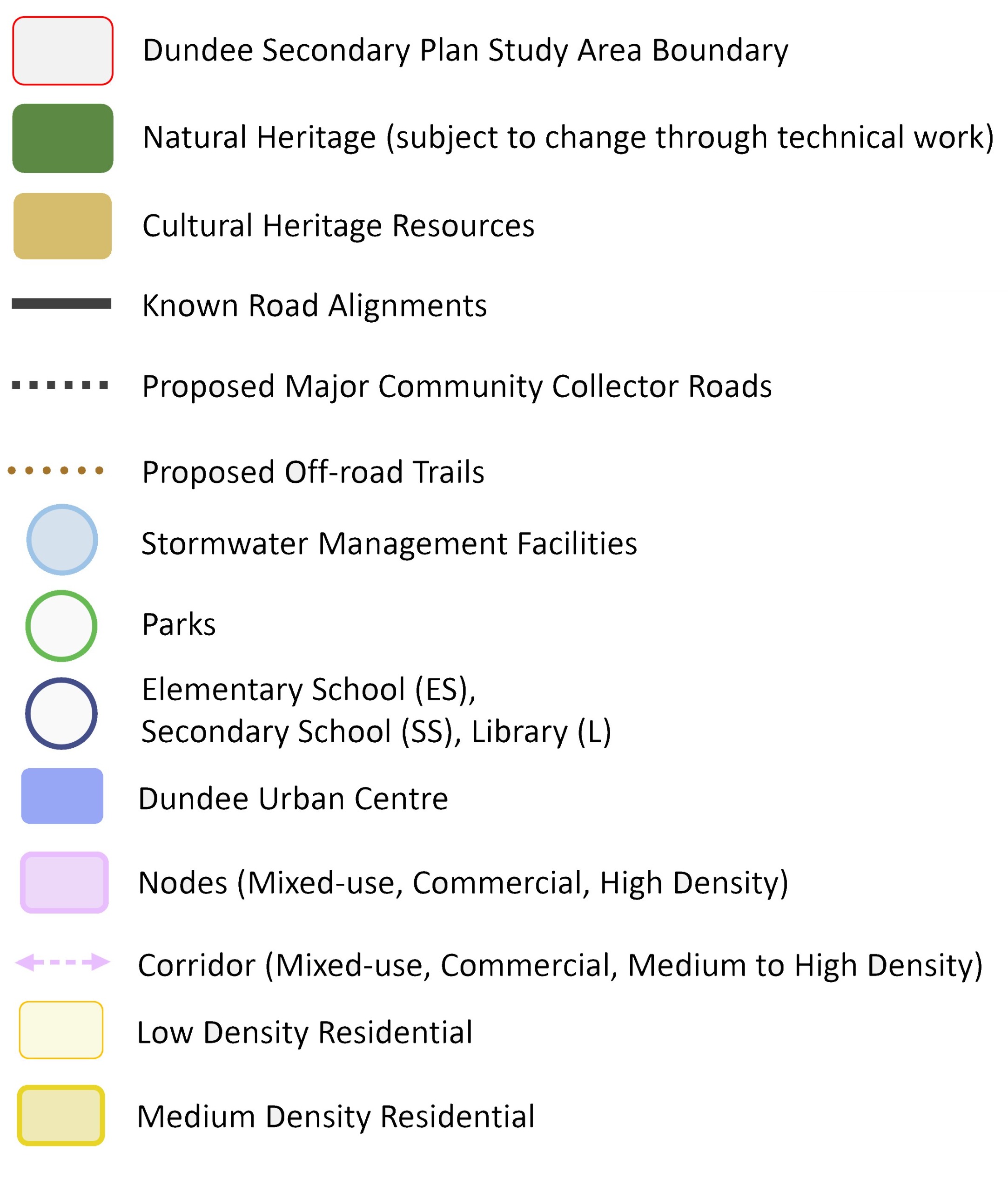
You will notice that both scenarios share several characteristics, including the following:
You will also see some subtle variations in the placement and distribution of land uses in the two options.
The two main differences are:
1. Placement of the Dundee Urban Centre
2. Number of schools
Click the 'layers' button in the top left-hand corner to turn the map layers on or off.
Click the 'layers' button in the top left-hand corner to turn the map layers on or off.
Earlier we introduced you to the Big Moves. Each move is further defined by a set of criteria and considerations for understanding whether the criteria were met.
For each Big Move, read the criteria and considerations. Then tell us which scenario best achieves that category.
Click the tabs to answer the polls for each one. When you’re done, refresh the page to see a summary of the responses from all visitors so far.
✅ Criteria
Provides opportunities for and encourages walking, cycling and/or rolling.
🤔 Considerations
Consider planned sidewalks and bike lanes as part of complete streets, off-road trails network, connections to natural heritage, length of blocks, distance between nodes, etc.
This poll has concluded.
⏩ Click the 'Transit' tab for the next poll.
✅ Criteria
Supports convenient access to transit. Includes roads that are transit-supportive that can integrate transit amenities.
🤔 Considerations
Consider planned sidewalks and bike lanes as part of complete streets, off-road trails network, connections to natural heritage, length of blocks, distance between nodes, etc.
This poll has concluded.
⏩ Click the 'Overall Connectivity' for the next poll.
✅ Criteria
Supports introduction of early transit service and provision of frequent transit service.
🤔 Considerations
Consider number of major intersections as proxy for transit stops, density and mix of use around potential transit stops, opportunity to expand service from/to surrounding communities.
This poll has concluded.
✅ Criteria
Provides a desirable amount and network of well-connected and usable park/public spaces that are adequately sized.
🤔 Considerations
Consider the planned amount and size of parks, network and connections between these parks and other uses throughout the community.
This poll has concluded.
⏩ Click the 'Stormwater' tab for the next poll.
✅ Criteria
Provides appropriate stormwater infrastructure. Serves multiple ecological benefits and support water resource systems.
🤔 Considerations
Consider locations where stormwater management can also serve multiple purposes, such as parks, recreational areas, and urban ecosystems.
This poll has concluded.
⏩ Click the 'Natural Heritage System' for the next poll.
✅ Criteria
Protects and enhances the natural heritage system and promotes compatible development abutting features.
🤔 Considerations
Consider if the existing natural heritage features are interconnected to work together to maintain and/or enhance biodiversity and ecological functions.
This poll has concluded.
⏩ Click the 'Cultural Environment' for the next poll.
✅ Criteria
Protects built heritage, cultural heritage resources / landscapes, archaeological resources, and support and / or create opportunities to advance conservation objectives.
🤔 Considerations
Considers if the cultural environment provides opportunities to understand, appreciate, and celebrate all cultures, including Indigenous.
This poll has concluded.
✅ Criteria
Promotes low energy use.
🤔 Considerations
Consider orientation of streets and blocks enhancing passive solar gains, mix of uses and densities to reduce vehicle dependency, conserving existing built heritage resources, prioritizing local food options.
This poll has concluded.
⏩ Click the 'Community Energy Supply' for the next poll.
✅ Criteria
Supports energy planning and generation including solar, geo-thermal or district energy systems.
🤔 Considerations
Consider infrastructure planning/investment that supports a diverse energy mix, including renewable sources, and enhances grid capacity and reliability, while also considering the needs of various uses.
This poll has concluded.
✅ Criteria
Is a destination 'hub' that is easily accessible and has a mix of uses, amenities, and/or services essential for community well-being, fostering social interaction, promoting physical activity, and enhancing the overall quality of life.
🤔 Considerations
Consider location relative to the community and surrounding areas, ability to accommodate a variety of uses, amenities and/or services that cater to different interests and age groups, ability to support higher densities and transit.
This poll has concluded.
✅ Criteria
Distinct and memorable areas act as visual and social anchors for a neighbourhood.
🤔 Considerations
Consider the concentration of higher density residential, mixed-use, commercial, in close proximity to schools, community facilities, etc. that encourage frequent travel.
This poll has concluded.
⏩ Click the 'Mix of Uses' tab for the next poll.
✅ Criteria
Provides a mix of uses to support the early introduction of transit, meet the day-to-day needs of residents and workers, and function as a complete community.
🤔 Considerations
Consider adequacy of mix of uses (residential, commercial, mixed-use, schools, parks, community facilities etc.) supporting the principles of complete communities.
This poll has concluded.
⏩ Click the 'Mix of Housing Types' tab for the next poll.
✅ Criteria
Provides a mix of housing types and tenure for all stages of life.
🤔 Considerations
Consider mix of housing types with a minimum 30% residential units in forms other than single-detached, semi-detached and townhouses.
This poll has concluded.
⏩ Click the 'Density' tab for the next poll.
✅ Criteria
Achieves appropriate densities to support transit and attract amenities, services, and businesses at desirable locations.
🤔 Considerations
Consider overall community density and densities achieved at key locations within the community to support early transit introduction.
This poll has concluded.
Tell us if there is anything we would need to add or change to best meet our growing community’s needs. If you see a comment you like, click the 'thumbs up'.
25 June, 2025
Michael says:
Cars should go around the urban centre instead of through it, option A is much better in this regard!
19 June, 2025
Austin says:
Add green corridors connecting parks, natural heritage land, SWM facilities, and trails
19 June, 2025
Austin says:
Keep houses and schools off of collector roads. Increase tree cover on all roads and tree density in parks.
19 June, 2025
Austin says:
Increase the amount of medium density, mixed use, and high density development, decrease low density residential!
18 June, 2025
JayD says:
Paramount importance: Prevent this from being a typical commuter suburb - we need novel approaches to architecture and the public realm.
18 June, 2025
ScottClark86 says:
I would like to see this area gain a new urban centre, which is pedestrian-centric. It seems we have forgotten how to build new downtowns.
18 June, 2025
ScottClark86 says:
I would like to see denser housing options available away from busy streets.
9 June, 2025
Mya says:
n/a
5 June, 2025
Justin says:
Fire Station
3 June, 2025
Les Misch says:
Potential indirect impacts from roads (i.e., water pollutants - road salt, hydrocarbons, chemicals, etc.) on Blair Creek and groundwater
3 June, 2025
Les Misch says:
Need to create ecological linkages/corridors that connect natural features to maintain biodiversity. Can integrate with SWMPs, parks, trails
3 June, 2025
Amy says:
More density is better, if Dundee will have an urban centre, go big or go home.
Also, grid roads and early transit coverage is good too.


