Laurelwood Multi-use Path
Consultation has concluded
Thank you to all who provided feedback, this project is now complete.
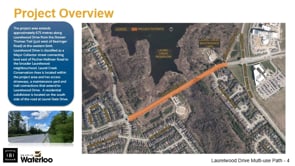
Welcome to this project page for the Laurelwood Drive multi-use path. The project area extends approximately 675m along the section of Laurelwood Drive between the Doreen Thomas Trail and Beaver Creek Road.
The primary objective is to develop a design for a multi-use path that will form part of the ultimate trail route around the perimeter of Laurel Creek Conservation Area. The proposed multi-use path will provide an all ages and abilities cycling connection through the project area with consideration for user comfort and safety, in addition minimize impact to existing infrastructure and the GRCA wetland and Laurel Creek Conservation Area.
Three different options were considered, with the chosen option selected for having the best balance in limiting impact to GRCA lands while maximizing function. This design option includes the following:
- three meter asphalt multi-use path
- a one meter wide boulevard street buffer
- existing east bound bike lane maintained (west bound bike lane removed)
- a two meter raised median located just west of Laurel Gate Drive to provide an opportunity for people to cross the street mid-block
More detailed information is now available in the Laurelwood Multi-use Path Construction Information document.
-
Construction update Spring 2021
Share Construction update Spring 2021 on Facebook Share Construction update Spring 2021 on Twitter Share Construction update Spring 2021 on Linkedin Email Construction update Spring 2021 linkThe final design has been completed for the Laurelwood Drive multi-use path. The contract has been tendered and awarded, and construction is expected to begin in June 2021. Due to COVID-19 precautions and restrictions, we're not able to hold an in-person information meeting before the construction begins. Full details including the images and contractor guidelines for work are available in Laurelwood Multi-use Path Construction Information.
The multi-use path will form part of the ultimate trail route around the perimeter of Laurel Creek Conservation Area, and look similar to the image below :

The construction work will include a new MUP along the north side of Laurelwood Drive between the Fischer-Hallman Road and Beaver Creek Drive. A pedestrian island will be added west of Laurel Gate Drive.

Construction includes the asphalt roadway, a bike lane, the multi-use path and a concrete median.

If you have any questions, please feel free to reach out to the project team.
Project Library

Presentation
Who's Listening
-
-
TM
-